

- Email link
- Read comments (19)
- Share:


Traveling the back roads of Stoddard County
Well, folks, I hate to give up on Minnie, but it looks as if she's gone off to Dance with the Stars, so I suppose we need to move on. In my continuing program to avoid any mention of what's going on in politics, I shall press on with other riveting topics of vital interest to this region of the country and to the often illogical workings of my own mind...
As a true child of the Heartland, I rely a lot on the back roads in this area to cut down on travel time. I don't have a good sense of direction, so I use familiar routes. I have a good friend I visit quite often in Sikeston, so I'm headed south at least once a week.
If it's daytime, sunny, and not flooded, I cut across through the hilly gravel roads to 91, go through Bell City, turn on N to Shady Dell, and take Y to Sikeston, crossing the "bottoms" - that enormous, flat, nearly desolate area of rice fields. I can usually make it to Sikeston in 30 minutes - tops, whereas going through Dexter, though more pleasant, can take me twice that.
The roller coaster roads on N don't seem to bother the people who whiz pass me, but I do not like those deep drainage ditches on each side, and I've sworn off coming home that way in the dark, especially when it's raining and water pools up on the road. For night trips, I prefer the Morley route, which is still pretty darn dark. If I don't pay close attention, I miss my turn-off and end up in Benton. Not good. Benton is also dark at night. Heck, once you leave those fancy lights coming out of Sikeston, all Southeast Missouri is DARK until you get to Cape!
Wednesday's choice of highway was unfortunate, because I got almost to Sikeston, only to discover that MoDot was doing bridge work on Y, and I had to figure out how to get around - no convenient gravel roads to take me to Hiway 60 like last time. Choices: 1) Turn around and go west to Avert, turn south on 25 to Dexter and then east on 60 to Sikeston. 2) Retrace my tracks on Y and hope it eventually angled east to 61.
My daughter would be pleased with this experience. I can just hear her: "Mom, it's good for your brain when you drive different routes!"
Yeah? I don't LIKE change! I have two recurring nightmares that have plagued me throughout my life. One is that I'm substitute teaching, and I open the door to find out that it's a MATH class. The other one is that I'm in my Jeep, driving along an unfamiliar road. I go over a hill and discover that the road has disappeared, and the only thing lying in front of me is a grassy hillside!
Since today was sunny and warm, I was only mildly perturbed and admittedly curious about where Hiway Y North would take me. I headed out, and, sure enough the highway angled East, past farmers combining beans. Reassuring. I should end up at 61 in familiar territory, I thought.
The cotton fields on my left told me I was entering Scott County, even before I saw the sign marking the county line.
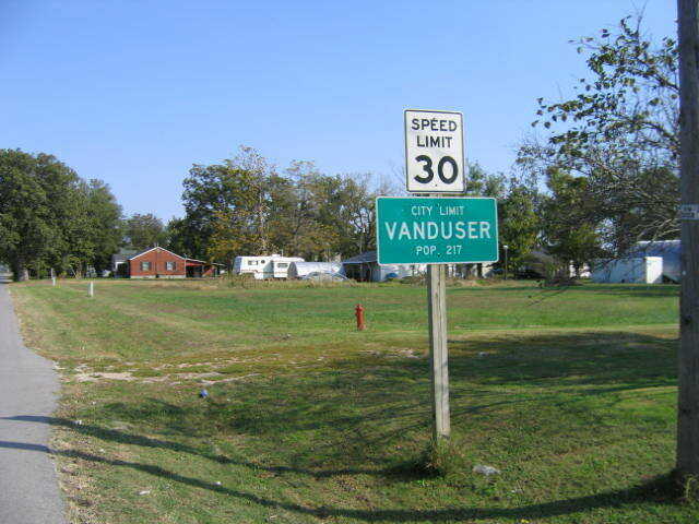
That's when I discovered Vanduser, a cute little town about half the size of Marquand or Bell City. I think the city limit sign reads "200-something." I had never been to Vanduser before, so my brain felt immensely enlarged with the experience. I do have a good friend who was once mayor of Vanduser and was even responsible for helping the town get a grant for a sewer system. That was the extent of my knowledge of Vanduser.
The town has no cross streets - only single streets branching off from what may have turned into highway Z. Not sure. You know how these roads intersect and run together for a ways and then leave each other to go off in opposite directions.
There appears to be an unusual Baptist Church there, and my Sikeston friend told me it was some sort of home for teens in crisis, I think. I marked it down in my mind to go back and do a story on it one day.
And, sure enough, a couple of miles on east brought me to Highway 61 and familiar territory. I drove only about 30-35 miles out of my way. Could have been worse.
Have you ever heard the saying, "You can't get there from here"? I think that applies to this region of the country.
However, now that I have filled in this geographical gap in my brain, I feel a little more confident in my ability to navigate the local terrain.
However, I still don't intend to try it at night. Things look totally different at night. Distances of a mile seem like 50. Time stretches out into eternity, and I feel as if I'm entering the Twilight Zone.
If I could afford On Star, I would certainly do it. There's something very reassuring about that television commercial in which someone is upside down in a ditch, and a calm, cultivated woman's voice says, "Mr. Jones, according to our system, you are experiencing some difficulties..." Ah....Help is on the way.
Unfortunately, such a Technological Wonder is beyond my reach, so I will just have to continue to navigate the back roads of Southeast Missouri, using my own flawed sense of direction, hoping that the roads aren't blocked by heavy equipment, water, wild herds of feral labs, mountain lions, or flocks of rabid flamingos.
Signing off from the brilliantly gold hills of North Stoddard County, this is your ever-roving rural reporter Madeline, glad to be home by the fire.
- Email link
- Read comments (19)
- Share:
Comments
Respond to this blog
Posting a comment requires free registration:
- If you already have an account, follow this link to login
- Otherwise, follow this link to register
After what seemed a long time, I came to a paved road, but there were no signs, and I still couldn't tell where I was. I saw more lights to the left than to the right, so I turned that way & drove toward the lights, trying to figure out what town it might be.
The city limits sign came closer and closer...and you guessed it: Advance! I had completely circled around and come out on the other side of town.
What an idiot!!
Everything looked totally different in the dark.